North-Western Territory
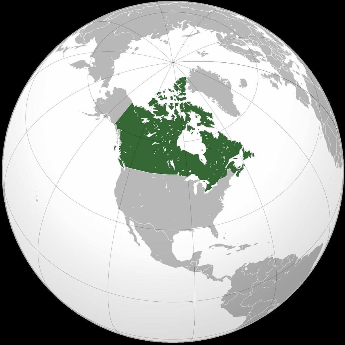
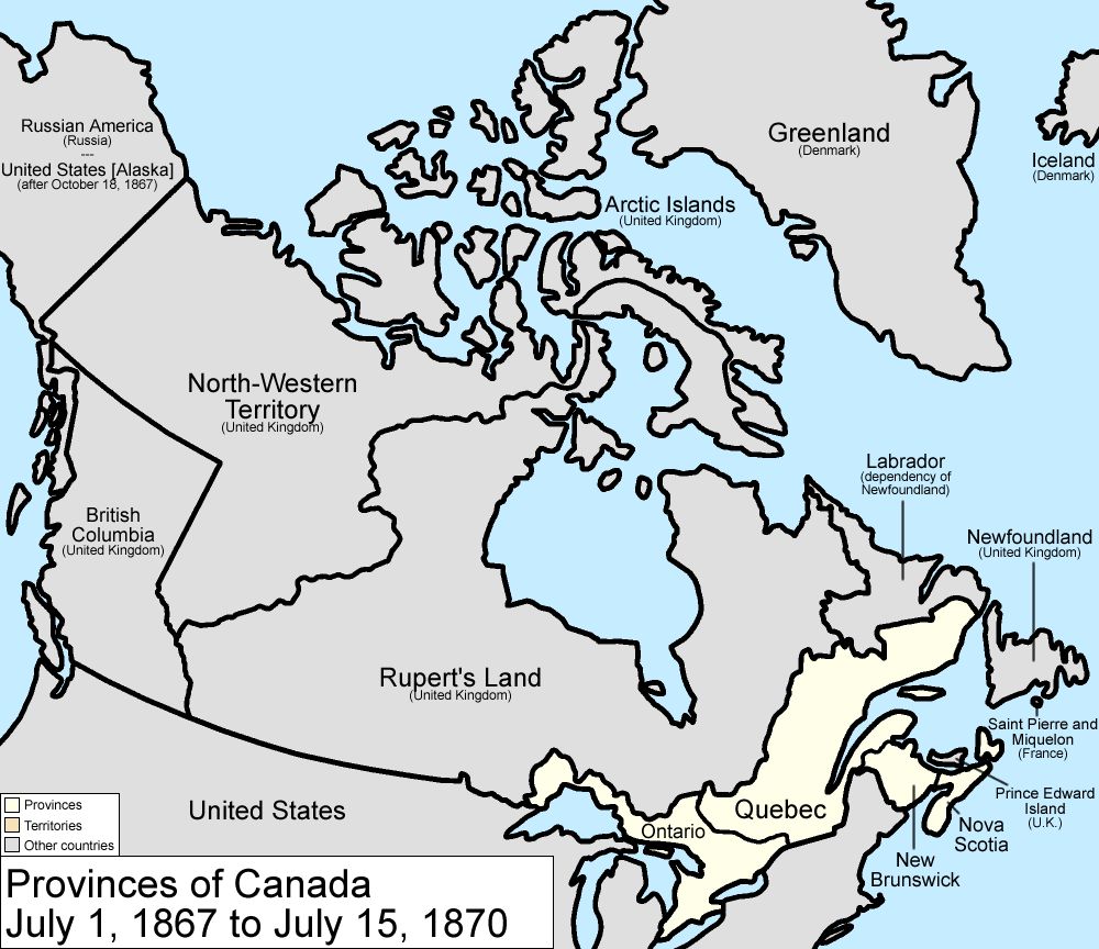
The North-Western Territory was a region of British North America that existed until 1870. It was named for its location relative to Rupert's Land. The territory's boundaries were not precisely defined. In modern usage, it is generally accepted as the region bounded by British Columbia, the continental divide with Rupert's Land, Russian America (later Alaska), and the Arctic Ocean. The territory included lands that later became the Yukon, mainland Northwest Territories, northwestern mainland Nunavut, northwestern Saskatchewan, and northern Alberta. It was not within the 1670 land grant to the Hudson's Bay Company, as it did not drain into Hudson Bay. However, the HBC was the de facto administrator. The territory was transferred to Canada from the HBC alongside Rupert's Land on July 15, 1870, forming the initial North-West Territories.
Definition and Ambiguous Boundaries
The North-Western Territory was not a colony or a territory with a formal, fixed administration. Its name described its geographical position relative to Rupert's Land. Maps varied in defining its limits. In modern historical usage, the region is generally accepted as the area bounded by British Columbia, the continental divide with Rupert's Land, Russian America (later Alaska), and the Arctic Ocean. This expanse contained lands that later became the Yukon, mainland Northwest Territories, northwestern mainland Nunavut, northwestern Saskatchewan, and northern Alberta. The southern limits were fluid, blending into the disputed western reaches of Rupert's Land. The legal ambiguity stemmed from the 1670 Hudson's Bay Company charter, which granted exclusive trade over Rupert's Land, defined as all lands draining into Hudson Bay. The North-Western Territory, lying beyond this watershed, was not included in the HBC's grant. Despite this, the company operated extensively within the region as a de facto extension of its domain. The British government never established an alternative administrative framework. This informal arrangement persisted until the transfer of sovereignty from the HBC to the Dominion of Canada in 1870. The territory's lack of defined borders was typical of many early North American claims.
Sovereignty and Fur Trade Administration
There is no definitive date for when Great Britain first asserted sovereignty over the North-Western Territory. British claims evolved gradually after France ceded its claims to the Hudson Bay region by the Treaty of Utrecht in 1713. This left Britain as the sole European power with practical overland access to the continental interior from the east. This brought it into conflict with the Montreal-based North West Company. To resolve the conflict, the British Parliament passed an act in 1821 that merged the two companies under the HBC name and extended the company's trading monopoly. The 1821 act, formally titled "An act for regulating the fur trade, and establishing a criminal and civil jurisdiction within certain parts of North America," assigned administrative duties over the vast interior to the Hudson's Bay Company. This gave the HBC de facto governmental authority over the North-Western Territory. The British government made almost no effort to assert direct sovereignty over the Indigenous nations inhabiting the region. In accordance with the Royal Proclamation of 1763, the government prohibited large-scale non-Indigenous settlement until the lands were formally surrendered by treaty, a process that would not begin until after the territory was transferred to Canada. For nearly five decades, the HBC operated as the sole governing and commercial entity across this immense region. The company's network of trading posts served as the primary centres of European influence and trade.
Boundary Disputes and the Stikine Territory
The undefined nature of the North-Western Territory's borders led to international and colonial disputes. The northern boundary with Russian America was formally set at the 141st meridian west by the Anglo-Russian Treaty of St. Petersburg in 1825. The Pacific coastal boundary remained a source of confusion. The region's isolation was shattered in 1862 by the Stikine Gold Rush, which brought American miners into the panhandle area. To prevent American annexationist sentiment, Governor James Douglas of the Vancouver Island and British Columbia colonies declared the area the Stickeen (or Stikine) Territory, carving it out of the North-Western Territory. The creation of this temporary territory highlighted the poorly defined coastal boundary. British claims were based on treaties from 1825 and 1839 that granted rights of free navigation on the Stikine River, as well as a lease of coastal lands to the south of it. The boundary was vaguely described as "ten marine leagues" from the sea, a measurement that was not properly surveyed. The year following the creation of the Stickeen Territories, part of the Stikine returned to the North-Western Territory when boundaries were adjusted and the Colony of British Columbia was extended to the 60th parallel north. This measure also brought into British Columbia its portion of the Peace River Block. The coastal boundary issue became central to the Alaska Boundary Dispute, which was settled by an international tribunal in 1903. The tribunal's decision largely favoured the United States.
Transfer to Canada and Creation of the North-West Territories
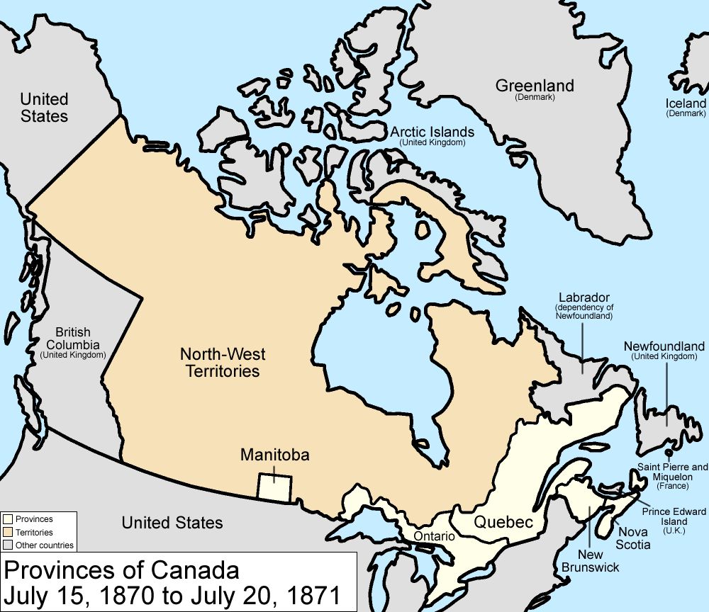
The most significant event in the history of the North-Western Territory was its transfer from the Hudson's Bay Company to the Dominion of Canada. Following Confederation in 1867, the Canadian government, led by Prime Minister John A. Macdonald, was determined to secure the western lands. In 1868, the HBC agreed to surrender its charter rights to Rupert's Land and its claim to the North-Western Territory. The deal was finalized for a purchase price of £300,000 (approximately CAD$1.5 million) and a grant of extensive tracts of land to the company. The transfer was made effective on July 15, 1870, by the Rupert's Land and North-Western Territory Order. On that date, the North-Western Territory ceased to exist as a distinct entity. It was merged with Rupert's Land and then immediately reconstituted, along with a small portion set aside to create the new province of Manitoba, as the North-West Territories. This new territorial government became the first Canadian territory. The federal government initially governed the NWT through an appointed Council and the Lieutenant-Governor of Manitoba, based in Winnipeg. The process was undertaken without consulting the Indigenous peoples of the region. The external boundaries of this new territory were subject to numerous changes as Canada's provinces expanded and other territories were carved out. The North-West Territories Act of 1875 later provided a more formal governmental structure for the territory.
Territorial Evolution and Provisional Districts
The North-West Territories created in 1870 were a massive administrative unit. The Canadian government soon began subdividing it for more effective governance. In 1876, the District of Keewatin was created in the eastern part of the territories. The British Arctic Territories were transferred to Canada by Britain on September 1, 1880, and were added to the NWT. The discovery of gold in the Klondike in 1896 prompted the federal government to separate the western region, creating the Yukon Territory in 1898. To manage the expected influx of settlers on the prairies, the government created a system of provisional districts within the southern NWT. In 1882, four districts were established: Assiniboia, Saskatchewan, Alberta, and Athabasca. This framework was expanded in 1895 with the creation of additional districts: Ungava, Mackenzie, Franklin, and a formal Yukon district just before it became a separate territory. Also in 1895, the boundaries of the Athabasca district were extended eastward into the District of Keewatin. These districts served as administrative units for federal agencies like the Department of the Interior and the North-West Mounted Police. They were not self-governing but facilitated the application of federal laws and policies.
- 1876: District of Keewatin created.
- 1880: British Arctic Territories added to the NWT.
- 1882: Provisional districts of Assiniboia, Saskatchewan, Alberta, and Athabasca created.
- 1895: Provisional districts of Ungava, Mackenzie, Franklin, and Yukon created. Athabasca boundaries extended.
- 1898: Yukon Territory separated from the NWT.
- 1905: Provinces of Alberta and Saskatchewan created from the NWT.
- 1912: Quebec, Ontario, and Manitoba boundaries extended north to their present locations, absorbing large parts of the old NWT.
Governance, Settlement, and Indigenous Relations
The governance of the North-West Territories was formally structured by the North-West Territories Act of 1875. This act provided a framework for a gradual transition from appointed to representative government as the non-Indigenous population grew. It established a separate Lieutenant-Governor and an appointed Council, with the territorial capital initially at Battleford in 1876 before moving to Regina in 1883. The Act also contained provisions for denominational (Protestant and Roman Catholic) school systems and for the official status of English and French. Administration was centralized under the federal Department of the Interior, established in 1873. Settlement was the federal government's primary focus for the southern prairie region. To facilitate this, it negotiated the Numbered Treaties with Indigenous nations between 1871 and 1877, covering the land from Lake of the Woods to the Rocky Mountains. These treaties were intended to secure peaceful access to land for agricultural settlement and resource development. The government also established the North-West Mounted Police in 1873 to assert Canadian law and order. The completion of the Canadian Pacific Railway in 1885 dramatically accelerated settlement. The population demographics shifted rapidly as a result. The 1885 census of the Assiniboia, Saskatchewan, and Alberta districts reported a total population of 48,362, of which 20,170 were Status Indians. The 1906 census for Saskatchewan and Alberta reported a population of 443,175, with Status Indians comprising 12,861. This stark change illustrates the deep impact of Canadian expansion and settlement policies on the Indigenous populations. The governance structures established in the 1870s laid the foundation for the modern political organization of Western and Northern Canada.
Modern Northwest Territories
The legacy of the North-Western Territory lives on in the modern Northwest Territories (NWT). The name is a direct descendant of the 1870 entity. The contemporary territory is a distinct jurisdiction within the Canadian federation, with its own elected Legislative Assembly and government. The capital is Yellowknife. The modern NWT is home to a diverse population including First Nations, Inuit, and Métis peoples, whose histories in the region long predate the fur trade and Canadian sovereignty. The Government of the Northwest Territories continues to manage the vast land and its resources, address unique northern challenges, and advance self-determination agreements. Recent activities illustrate the ongoing governance of the territory. In October 2026, Premier R.J. Simpson announced the appointment of Brad Patzer as Deputy Minister of Justice, effective November 2, 2026. The territorial government also amended the Petroleum Products and Carbon Tax Regulations in 2026 to adjust rebates for large emitters. The NWT Association of Communities presented its 2026 community awards in February of that year. The territory hosts events that blend community and history, such as the Northwest Territorial Days amusement park event in August 2026 and the 2026 Project Management Conference scheduled for December in Yellowknife. These contemporary events occur in a political setting still shaped by the historical processes that began with the acquisition of the North-Western Territory.
Questions about North-Western Territory
What was the North-Western Territory?
The North-Western Territory was a region of British North America that existed until 1870, named for its location relative to Rupert's Land. Its boundaries were not precisely defined. It included lands that later became the Yukon, mainland Northwest Territories, northwestern mainland Nunavut, northwestern Saskatchewan, and northern Alberta. It was under the de facto control of the Hudson's Bay Company and was transferred to Canada in 1870 to form the initial North-West Territories.
When did the North-Western Territory become part of Canada?
The North-Western Territory officially became part of Canada on July 15, 1870. On that date, the Hudson's Bay Company's surrender of its charter rights to Rupert's Land and its claims to the North-Western Territory took effect under the Rupert's Land and North-Western Territory Order. The Canadian government purchased these lands for £300,000 (CAD$1.5 million) and a large land grant. Immediately upon transfer, the territory was combined with Rupert's Land and reconstituted as the North-West Territories.
What was the Stikine Territory and how was it related?
The Stikine Territory was a short-lived administrative region carved out of the North-Western Territory in 1862. It was created by Governor James Douglas in response to the Stikine Gold Rush, which brought an influx of American miners. Douglas established the territory to assert British sovereignty and prevent potential American annexation claims. Part of it returned to the North-Western Territory when boundaries were adjusted and British Columbia was extended north to the 60th parallel.
How was the North-Western Territory governed before 1870?
Before 1870, the North-Western Territory had no formal colonial government. De facto administrative control was exercised by the Hudson's Bay Company. Following the merger of the HBC and the North West Company in 1821, the British Parliament passed an act that granted the HBC administrative duties and jurisdiction over the fur trade lands, which included the North-Western Territory. The British government itself made little effort to enforce direct sovereignty or establish treaties with Indigenous nations in the area prior to the transfer to Canada.
What happened to the North-Western Territory after 1870?
After July 15, 1870, the North-Western Territory ceased to exist as a distinct entity. It was merged into the newly created North-West Territories (NWT). This massive territory was then repeatedly subdivided. Key events included the addition of the Arctic Islands in 1880, the creation of the Yukon Territory in 1898, the establishment of the provinces of Alberta and Saskatchewan in 1905, and the northward expansion of Manitoba, Ontario, and Quebec's boundaries. The residual portion became the present-day Northwest Territories.
What modern Canadian areas were part of the North-Western Territory?
The North-Western Territory comprised lands that later became the Yukon, mainland Northwest Territories, northwestern mainland Nunavut, northwestern Saskatchewan, and northern Alberta. In modern usage, the region is generally accepted to be the area bounded by British Columbia, the continental divide with Rupert's Land, Russian America which later became Alaska, and the Arctic Ocean. The entire region was transferred to Canada alongside Rupert's Land on July 15, 1870. This transfer was enacted under the Rupert's Land and North-Western Territory Order.
Sources and further reading
- North-Western Territory (Wikipedia)
- North-West Territories (1870 to 1905) (thecanadianencyclopedia.ca)
Checked by the Nosy Mag desk. Last updated 2026-10-28.