Stó꞉lō
The Stó꞉lō are a Coast Salish First Nation whose traditional territory, known as S'ólh Téméxw, encompasses the Fraser Valley and lower Fraser Canyon of British Columbia. Their name, meaning "river people" in the Halq'eméylem language, reflects their deep historical and cultural connection to the Fraser River watershed. With a population of approximately 8,876 people, the Stó꞉lō are a collective of distinct communities and families who have inhabited the region for at least 10,000 years. Their history includes deep cultural traditions, devastating early contact with European diseases, and a long struggle for land rights and cultural revitalization that continues to shape their relationship with Canada today.
Origins and Deep History
The Stó꞉lō trace their origins in S'ólh Téméxw back to the early Holocene period, with archaeological evidence confirming continuous occupation for 5,000 to 10,000 years. Early inhabitants were highly mobile hunter-gatherers, with significant sites including the Milliken site in the lower Fraser Canyon and the Glenrose Cannery site near the river's mouth, where people harvested deer, elk, seals, salmon, and shellfish. Stó꞉lō oral tradition describes their connection to the land through the concept of Tel Swayel (sky-born people) or Tel Temexw (earth-born people), and through the actions of the Xexá:ls, who fixed the world and shaped the landscape from ancestral beings like the beaver, mountain goat, and sturgeon. This spiritual geography means Stó꞉lō identity is intrinsically linked to the physical and changed features of their territory, a connection summarized in the elder's statement, "we have always been here." The archaeological record shows a transition to more sedentary village life with permanent house sites beginning between 5,000 and 4,000 years ago, a shift that coincided with the first appearance of the Coast Salish woolly dog in the region.
Archaeology and Pre-Contact Society
Archaeological investigations reveal a complex and evolving Stó꞉lō society long before European contact. The middle Holocene period, from about 5,500 to 3,000 years ago, saw increased cultural complexity, the introduction of permanent house construction, and the first appearance of the now-extinct Coast Salish woolly dog. One of the most significant and oldest sites is Xá:ytem at Hatzic, near Mission, which features a large transformer stone and evidence of village life from two major eras, one around 3000 years before present and another from 5000 to 9000 years before present. The site demonstrates advanced posthole and timber-frame construction and social organization before it was abandoned and buried by Fraser River sediments. Another enigmatic set of structures, the Fraser Valley Pyramids or Scowlitz Mounds near Harrison Bay, are distinct burial mounds containing internal timber structures to sustain the mound's weight, though their builders may not have been forebears of the Stó꞉lō peoples. The late pre-contact period, from 3,000 years ago onward, is marked by new forms of ground stone technology like slate knives, slate points, hand mauls, nephrite chisels, and nephrite adzes, indicating craft specialization, expanding households, and increased social stratification and warfare.
Contact, Disease, and Colonial Encroachment
The first devastating contact with Europeans was indirect, through the spread of infectious disease. A smallpox epidemic reached the Stó꞉lō in late 1782, likely via coastal trade routes, and killed an estimated two-thirds of the population within six weeks. Traditional healing practices, which involved gathering around the sick to sing and pray, and cleansing sweats followed by cold morning baths, exacerbated the spread and shocked infected bodies. Survivors were often left blind or with other permanent disabilities, making hunting difficult and leading to widespread hunger and emotional damage. The decimation of the community also caused the loss of large amounts of important cultural information held in the oral tradition. Subsequent epidemics of measles, mumps, tuberculosis, and influenza further reduced the population. The first direct European exploration was by Simon Fraser in 1808, followed by the establishment of the Hudson's Bay Company's Fort Langley in 1827 and Fort Yale in 1848. While initially a fur trade post, Fort Langley quickly pivoted to trading salmon, purchasing 200 barrels in 1830 and over 2,610 barrels by 1849. The Kwantlen branch relocated their main village near the fort for trade primacy and protection from northern slave raiders like the Euclataws of Quadra Island. The subsequent Fraser Canyon Gold Rush of 1858 brought over 30,000 miners, creating immediate conflicts over land and resources, followed by whiskey peddlers and then permanent immigrant farmers.
The Douglas and Trutch Era
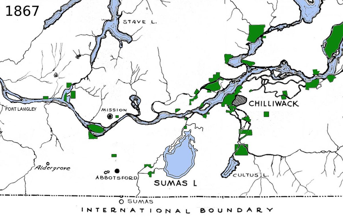
Governor James Douglas recognized the land disputes between miners and the Stó꞉lō and attempted to create separate territories, beginning a long history of formal land disputes. His plan involved the assimilation of the Stó꞉lō into European culture through agricultural development on pre-empted crown land and the leasing of reserve lands to non-Aboriginal farmers. While waiting to negotiate treaties, he directed the creation of large Indian reserves of at least 40 hectares per family. Sergeant William McColl surveyed these reserves in 1864, outlining 15,760 hectares through present-day Abbotsford, Chilliwack, and Mission, which included berry patches, transformer sites, and burial grounds identified by the Stó꞉lō themselves. Douglas also promised fair compensation for all land outside the reserves occupied by settlers. After Douglas retired and McColl died, Joseph Trutch, the Chief Commissioner of Lands and Works, took charge. Trutch believed the Stó꞉lō did not need land not used for agrarian purposes and reduced the reserves by ninety-one percent in 1867, siding with settlers who had built homes and farms on the land. He also revoked Stó꞉lō rights to participate in government or to pre-empt or purchase land outside the reserves. This series of actions established the unresolved land question that the British Columbia government only began to formally address through the BC Treaty Commission in 1990.
Residential Schools and Cultural Suppression
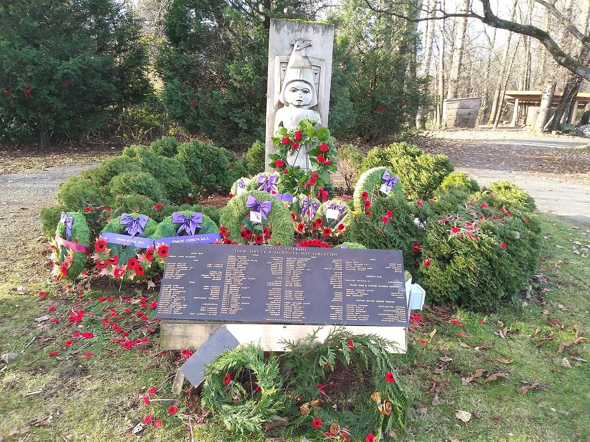
The St. Mary's Indian Residential School in Mission, operated first by the Roman Catholic Church and later by the federal government, was a central institution of assimilation for Stó꞉lō children, with approximately 2,000 students passing through its doors. Opened in 1863 for boys and adding a girls' section in 1868, the school prohibited the speaking of Halq'eméylem, enforcing English through corporal punishment. The curriculum initially focused on Catholic catechism and academics before shifting toward agricultural and industrial training in woodworking, attending mass, ironing, and sewing. Parents were allowed to visit and some camped around the school, and students could visit the city of Mission until 1948. Upon arrival, students were assigned lockers and beds, checked for lice, and given two sets of marked clothes. While accounts of conditions vary by era, with historian Terry Glavin noting no corporal punishment in the 1800s, strapping became routine in later periods. The school moved to a new government-run facility in 1961, and all buildings were demolished in 1985, making it the last residential school in British Columbia to be destroyed. The grounds, now part of Fraser River Heritage Park, were returned to Stó꞉lō governance in 2005, formally regaining the name Pekw'xe:yles (Peckquaylis) and receiving Indian reserve status.
- 1863: St. Mary's opens as a boys' school with 42 students.
- 1868: A girls' section is added, later operated by the Sisters of St. Ann.
- 1882: The girls' school relocates for Canadian Pacific Railway construction.
- 1952: 16 students graduate with full grade 12 diplomas.
- 1961: Students move to a new government-run school. Original Catholic school closes.
- 1985: All buildings of the former schools are demolished.
- 2000: New Bell Tower is constructed on the site, housing the original 1875 bell.
- 2001: Mission Indian Friendship Centre funds a covered picnic shelter in the park.
- 2005: The school grounds are returned to the Stó꞉lō and given reserve status as Pekw'xe:yles.
Language Revitalization and Cultural Renewal
The Halq'eméylem language, the Upriver dialect of Halkomelem, is critically endangered, with fewer than five fluent speakers remaining, all of whom are elderly. Of the 278 fluent speakers of all Halkomelem dialects, the number for Halq'eméylem is particularly low and decreases each year. The deliberate suppression of the language at institutions like St. Mary's Residential School, where students were punished physically or mentally for speaking it, severed intergenerational transmission for decades. In response, the Stó꞉lō Shxweli Halqʼeméylem Language Program was established in 1994 under the Stó꞉lō Nation's Community Economic Development education department with the goals of teaching community members and developing curriculum. The program has since partnered with post-secondary institutions including the University of the Fraser Valley, Simon Fraser University, and the University of British Columbia to offer courses to students regardless of background. A major technological initiative involves archiving the language on the First Voices mobile and website application, which currently hosts 1,745 words and 667 phrases in Halq'eméylem. This comprehensive effort aims to revive a core element of Stó꞉lō identity and ensure its survival for future generations.
Modern Political Organization and Governance
Contemporary Stó꞉lō political structures emerged in response to federal policies, particularly the 1969 White Paper that aimed to end benefits for Status Indians and assimilate Aboriginal people. In the 1960s, DIA Indian Agencies became District Councils, leading to the formation of the East Fraser District Council, a grouping of twenty-four Stó꞉lō communities between Fort Langley and Yale. The Chilliwack Area Indian Council was formed in 1970 when the local DIA office closed, initially representing 21 communities and by 1975 having 14 member communities with an executive team of Chief Richard Malloway of Yakweakwioose, Chief Sam Douglas of Cheam, and Chief Andrew Alex of Union Bar. Between the early 1970s and 1994, several political and service delivery organizations grew, including the Stó꞉lō Forum and Stó꞉lō Political Branch. Chief Steven Point proposed amalgamating all Stó꞉lō service agencies as early as 1980. In 1994, Stó꞉lō Nation Canada and the Stó꞉lō Tribal Council agreed to form a single organization under Point's leadership. The Stó꞉lō Nation submitted its Statement of Intent to the British Columbia Treaty Commission in 1995, asserting collective rights from the Dry Rack Fishery above Yale to the Salish Sea. Twenty-one communities, led by chiefs including Charles Douglas, Michelle Douglas, and Lester Ned, formed the first Board of Directors known as the Special Chiefs Council.
- 1960s: Formation of the East Fraser District Council (EFDC).
- 1970: Chilliwack Area Indian Council (CAIC) forms after local DIA office closure.
- 1975: CAIC executive includes Chief Richard Malloway, Chief Sam Douglas, and Chief Andrew Alex.
- 1980: Chief Steven Point proposes amalgamation of all Stó꞉lō service agencies.
- 1994: Stó꞉lō Nation Canada and Stó꞉lō Tribal Council agree to unify.
- 1995: Stó꞉lō Nation submits Statement of Intent to BC Treaty Commission (June 30).
- 1995-96 Fiscal Year: Stó꞉lō Nation operates with a total budget of $18,174,722.00.
- 2001: Child welfare responsibility transfers from the Ministry of Children and Families to Stó꞉lō Nation.
- 2003: New facility for Head Start and Day Care Programs completed (November 28).
- 2004: Health Facility opens. Eight member communities withdraw, forcing organizational changes.
- 2005: Internal reorganization. Eight communities form the separate Stó꞉lō Tribal Council.
Economic and Community Development
Stó꞉lō economic initiatives focus on creating sustainable employment and fostering self-determination. The Sto:lo Aboriginal Skills & Employment Training (SASET) organization is central to this effort, providing employment services to underemployed or unemployed Indigenous people in a catchment area from Katzie and Langley to Boston Bar, including the Stlatl'imx communities of Samahquam, Skatin, and Xa’xtsa. SASET's goal is to create quality training and access to employment through identifying client needs, offering skills development funding for specific training, and delivering core programs. These programs include Construction Foundations, Basic Security Training, Customer Service, Safety Certificates (WHMIS, FoodSafe, OFA), Transportation Endorsement, Fall Protection, Confined Space training, Traffic Control Person Certification, Health Care Assistant, Wildfire Certificate Training, Warehousing Certification, Foundations in Landscaping, and Maintenance Worker Certification. The organization runs an annual call for proposals in November to support communities and businesses in creating employment outcomes. Key community infrastructure developments include the opening of the Shxwt'a:selhawtxw Longhouse Extension Program on April 16, 1995, and the Stó꞉lō Government House on September 10, 1999. The Coqualeetza Cultural Education Centre, located on the site of the former Coqualeetza Indian Hospital which operated from 1941 to 1969, serves as an important hub for cultural and educational programming.
The Stó꞉lō Collective and Land Management
The Stó꞉lō Collective is a key modern governance body defined by a Terms of Reference document that outlines its purpose, structure, and decision-making processes for advancing shared priorities related to lands, governance, and collective interests. The Collective focuses on the management and development of three major properties: Pekw'xe:yles (the former St. Mary's site), Coqualeetza, and the Xá:ytem archaeological site. Its work involves practical matters such as the Coqualeetza Sewer Project, Right of Way Fund Distribution, Land Use Planning, and exploring a collective land code. A significant achievement is the submission and acceptance by Indigenous Services Canada of all 21 Band Council Resolutions for Additions to Reserve related to the Coqualeetza lands. Meetings are typically opened with a prayer led by a community leader such as Chief Darcy Paul or Chief Norman Florence, and discussions cover topics ranging from quorum requirements and community representatives to updates on the Xyólheméylh modular project and community impacts from flooding. The Collective also deals with administrative matters like property management, decision-making processes, and the distribution of funds held in trust due to trespass. It represents a collaborative model for Stó꞉lō nations to work together on land stewardship and economic development, guided by a vision for social, political, economic, and cultural development.
Population, Structure, and Service Delivery
The Stó꞉lō are not a single band but a collective of many distinct First Nations communities and families. The total Stó꞉lō population is approximately 8,876 people. The modern political scene involves multiple overlapping organizations with specific roles. The Stó꞉lō Nation Chiefs Council represents a broad coalition of communities and operates with a complex internal structure. By the 2003 to 2004 fiscal year, Chief Executive Officer Joe Hall oversaw several programs and services, while individual directors managed Financial Services, Administrative Services, Child and Family Services, Health Services, and Community Development. Portfolio holders at that time included Chief Lydia Archie, Councilor Ken Malloway, Chief Doug Kelly, Stó꞉lō Siyá:m Tyrone McNeil, and Stó꞉lō Yewal Siyá:m Clarence Pennier. The Stó꞉lō Service Agency is the primary vehicle for delivering community programs in health, social assistance, and education, evolving from the earlier Chilliwack Area Indian Council which was the first Stó꞉lō authority delegated to administer DIA benefits. The Stó꞉lō Tribal Council is a separate entity comprising eight specific nations: Cheam, Chawathil, Kwantlen, Kwaw-kwaw-Apilt, Scowlitz, Seabird Island, Shxw'ow'hamel, and Soowahlie. This complex structure reflects both the diversity of Stó꞉lō communities and their shared efforts to advance common interests in land rights, cultural preservation, and economic development within their traditional territory of S'ólh Téméxw.
Questions about Stó꞉lō
Who are the Stó꞉lō people?
The Stó꞉lō are a Coast Salish First Nation whose name means "river people" in the Halq'eméylem language. Their traditional territory, S'ólh Téméxw, spans the Fraser Valley and lower Fraser Canyon in British Columbia. They are a collective of distinct communities and families with a deep history in the region dating back at least 10,000 years. Today, they are actively engaged in cultural revitalization, land rights negotiations, and community development through organizations like the Stó꞉lō Nation Chiefs Council and the Stó꞉lō Service Agency.
What is the significance of the Fraser River to the Stó꞉lō?
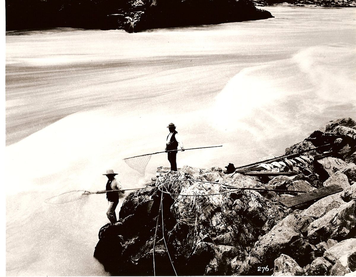
The Fraser River is central to Stó꞉lō identity, sustenance, and culture. Their name literally translates to "river people," and their traditional life revolved around the river's resources, particularly salmon. Important ceremonies, such as the First Salmon ceremony, were dedicated to the salmon's life cycle. Historically, villages were located along the Fraser and its tributaries like the Chilliwack and Harrison Rivers for access to water, fishing, and transportation. The river shaped their economy, diet, and spiritual practices, making it the heart of S'ólh Téméxw.
What happened at the St. Mary's Residential School?
St. Mary's Indian Residential School in Mission was operated by the Roman Catholic Church and later the federal government from 1863 to 1961, with approximately 2,000 Stó꞉lō children in attendance. The school enforced assimilation by prohibiting students from speaking Halq'eméylem, punishing them for using their language, and focusing curriculum on Christian teachings and manual labour. Accounts of physical and mental abuse vary by era, but conditions were harsh for many. The buildings were demolished in 1985, and the land was returned to Stó꞉lō governance in 2005, now known as the Pekw'xe:yles reserve, a site of reclamation and memory.
Is the Stó꞉lō language still spoken?
The traditional Stó꞉lō language, Halq'eméylem, is critically endangered. There are fewer than five fluent speakers remaining, all of whom are elderly, due to decades of suppression in residential schools. However, significant revitalization efforts are underway. The Stó꞉lō Shxweli Halqʼeméylem Language Program, established in 1994, teaches the language, develops curriculum, and partners with universities. The program has archived 1,745 words and 667 phrases on the First Voices application.
What is the Stó꞉lō Nation's relationship with the BC Treaty Process?
The Stó꞉lō Nation Chiefs Council submitted a Statement of Intent to the British Columbia Treaty Commission in 1995, asserting their collective Aboriginal rights and title. However, the Stó꞉lō political scene is complex. In 2005, eight member communities, including Cheam and Kwantlen, formed the separate Stó꞉lō Tribal Council, which does not participate in the formal BC treaty process. Meanwhile, the broader Stó꞉lō Collective focuses on managing shared lands and properties, indicating a multi-faceted approach to advancing sovereignty and land rights.
What are some key Stó꞉lō archaeological sites?
Several archaeological sites attest to the long history of the Stó꞉lō. The Xá:ytem site at Hatzic, near Mission, is one of the oldest, with evidence of village life dating from 5000 to 9000 years before present, centered around a large transformer stone. The Milliken site in the Fraser Canyon and the Glenrose Cannery site near the river's mouth show early hunter-gatherer settlements. The enigmatic Fraser Valley Pyramids or Scowlitz Mounds near Harrison Bay are distinct burial mounds with internal timber structures, though their builders' relationship to the Stó꞉lō is not fully understood.
Sources and further reading
- Stó꞉lō (Wikipedia)
- Stó:lo Tribal Council, Province of British Columbia (www2.gov.bc.ca)
- Stó:lō Service Agency (stolonation.bc.ca)
- Resources | Stó:lō Collective (stolocollective.ca)
- Sto:lo Aboriginal Skills & Employment Training, Home (saset.ca)
Checked by the Nosy Mag desk. Last updated 2026-10-29.