Vinland Map
The Vinland Map is a 20th-century forgery that was presented to the world in 1965 as a purported 15th-century world map depicting Norse exploration of North America. For decades, it was celebrated as potentially the earliest cartographic representation of what is now Canada, specifically showing a landmass labelled 'Vinland' southwest of Greenland. The map's revelation came just five years after the archaeological discovery of the Norse site at L'Anse aux Meadows in Newfoundland, seeming to provide dramatic corroboration of Viking voyages to the Americas. After more than half a century of intense scholarly debate and scientific investigation, specialists at Yale University conclusively declared it a modern forgery in 2018, a finding that closed one of the most famous controversies in the history of cartography and North American exploration.
Discovery and Acquisition
The Vinland Map first surfaced in 1957, three years before the confirmed discovery of the Norse settlement at L'Anse aux Meadows. It was bound within a slim volume containing a medieval text known as the Tartar Relation. London book dealer Irving Davis, acting for Spanish-Italian dealer Enzo Ferrajoli de Ry, unsuccessfully offered it to the British Museum. American dealer Laurence C. Witten II subsequently purchased the volume from Ferrajoli for $3,500 and offered it to his alma mater, Yale University. Initial suspicion arose because wormholes in the map did not match those in the accompanying Tartar Relation manuscript. This mystery was partially resolved in early 1958 when Yale librarian Thomas Marston acquired a damaged medieval copy of Vincent of Beauvais's Speculum Historiale from Irving Davis. The wormholes in this new manuscript showed it had once contained both the map at its beginning and the Tartar Relation at its end, linking the three items. Most traces of former ownership had been carefully removed from the manuscripts, a point later scrutinized by historians.
Yale University was interested but could not afford Witten's asking price and was concerned by his refusal to disclose the map's provenance. The university contacted alumnus and philanthropist Paul Mellon, who agreed to purchase the map for approximately $300,000 and donate it to Yale on the condition it could be authenticated. Mellon insisted on absolute secrecy until a scholarly book could be prepared, limiting consultation to only a handful of individuals. The authors chosen for this book were Raleigh Ashlin Skelton, keeper of the British Museum's map collection, his colleague George Painter, and Thomas Marston. After years of private study, Paul Mellon donated the map to Yale in 1964. The accompanying book, The Vinland Map and the Tartar Relation, was published and the map was revealed to the world on October 11, 1965, the day before Columbus Day, creating an immediate international sensation.
Content and Initial Scholarly Doubts
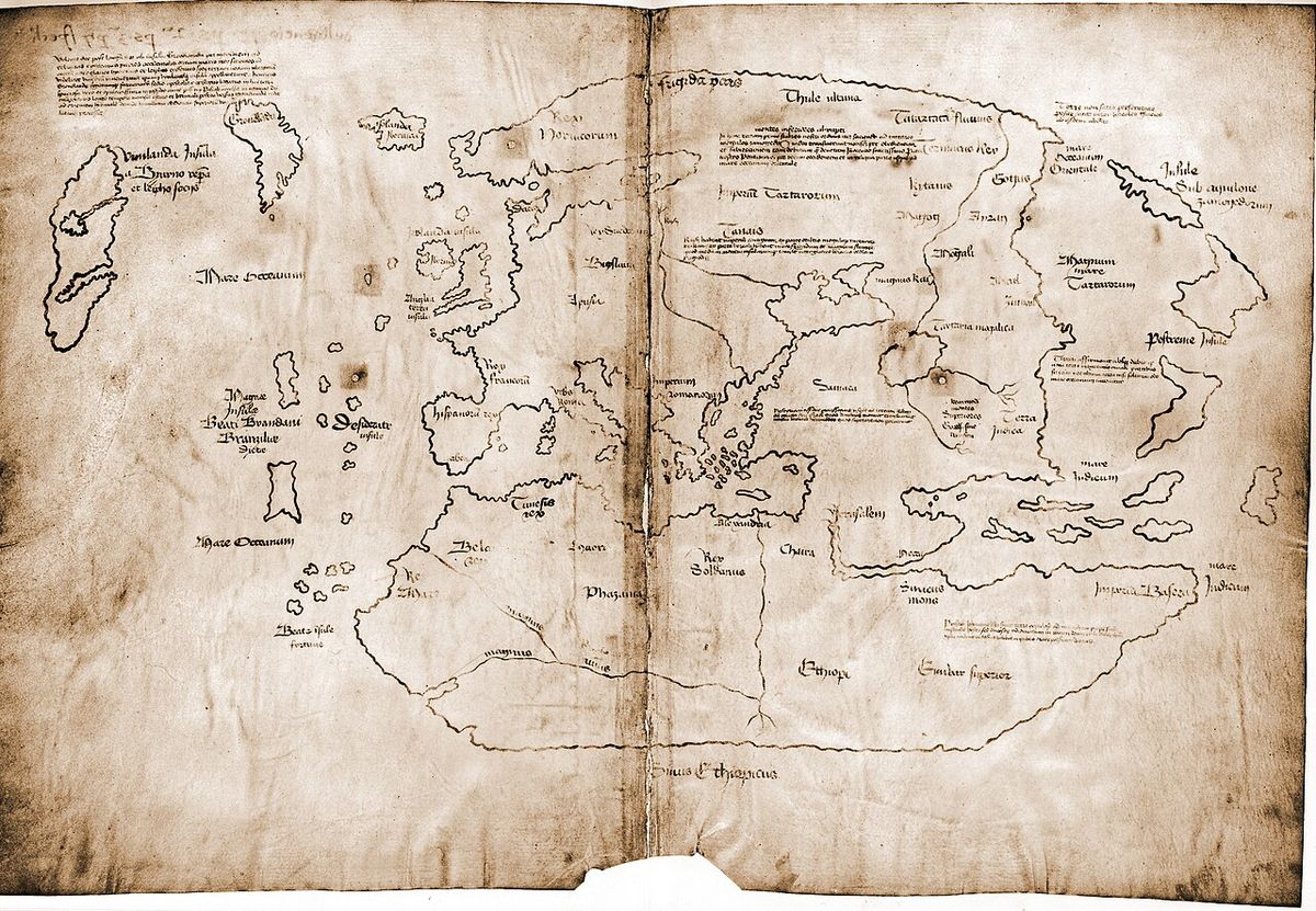
The map is a simple line drawing, unusually spartan compared to typical illuminated medieval manuscripts. It depicts Africa, Asia, and Europe, but its most notable feature is a large island in the Atlantic southwest of Greenland, labelled 'Vinlanda Insula'. The map includes Latin captions describing this region as having been visited by Europeans in the 11th century. One caption refers to Bishop Eirik of Greenland 'and neighboring regions' (regionumque finitimarum). The map's content raised immediate red flags among experts who saw photographs. It bore a strong but imperfect resemblance to a 1430s map by Italian mariner Andrea Bianco, even copying the point where Bianco's map had a page fold. Most surprisingly, it depicted Greenland as an island with a shape and orientation remarkably close to reality, a geographical feat not achieved on any other known medieval map, where Greenland was typically shown as a peninsula of northern Russia.
Scholars identified several anachronisms in the text. The Latin form of Leif Erikson's name, 'Erissonius', was more consistent with 17th-century norms. The use of the Latin ligature 'æ' in the captions was almost unknown in later medieval Gothic script, being a revival by Italian humanist scholars. The phrase describing Bishop Eirik's jurisdiction was traced by researcher Peter Foote directly to the work of early 20th-century religious scholar Luka Jelić. It appeared the map's creator had either copied Jelić's anachronistic scholarly description or Jelić had secretly seen the map and never mentioned it, the former being far more likely. At a major conference on the map held at the Smithsonian Institution in 1966, handwriting experts also disputed Witten's claim that the map captions were written by the same scribe as the Speculum Historiale and Tartar Relation texts.
Scientific Investigations and the Ink Analysis
The first major scientific analysis of the map's ink began in 1972. Yale sent the map to forensic specialist Walter McCrone, whose team used microscopy and other techniques to analyze the ink. They made a critical discovery: the yellowish lines contained anatase, a specific crystalline form of titanium dioxide. This form of anatase was a synthetic pigment manufactured for use in pale-coloured paints only since the 1920s. McCrone's team also found the ink contained only trace amounts of iron, and that remnants of a black line sat on top of the yellow ink, disproving an early theory that the yellow was over a faded iron-gall guide. This evidence strongly pointed to a 20th-century origin for the ink. A subsequent investigation in the early 1980s by a team at the University of California, Davis, led by Thomas Cahill, used particle-induced X-ray emission (PIXE) and initially reported only trace amounts of titanium. This created a temporary controversy, but later re-evaluation showed the Cahill team's PIXE data was flawed, with their measurements for all elements in the ink being at least a thousand times too low.
Later analyses consistently supported McCrone's findings. In 1991, McCrone took new samples and used photomicrographs to prove the anatase particles were embedded within the ink layer, not merely surface contamination. In 2002, British researchers Katherine Brown and Robin Clark used Raman spectroscopy to confirm the presence of significant anatase and identified the remaining black pigment as soot-based carbon. Various theories were proposed to explain how 20th-century anatase could appear in a medieval ink, such as contamination from clay or a byproduct of medieval ink-making. However, detailed examination showed the anatase crystals in the map were the neat, rounded manufactured type, distinct from the irregular crystals produced in medieval process experiments or found in natural clay. The scientific consensus became overwhelming: the ink was modern.
The Parchment and the 2018 Yale Declaration
Complicating the story was the age of the parchment itself. Radiocarbon dating in 1995 established the parchment was genuinely from between 1423 and 1445. This finding indicated a forger had used a genuine, blank piece of medieval parchment, likely removed from an old manuscript. Researchers also found the parchment contained tiny traces of radioactive fallout from 1950s nuclear tests, absorbed before the ink was applied. The definitive modern analysis came from Yale University itself in 2018. A months-long forensic investigation led by Raymond Clemens, curator of early books at Yale's Beinecke Library, provided the final, conclusive evidence of forgery. The team discovered that a Latin inscription on the back of the parchment, a bookbinder's instruction, had been chemically erased and overwritten with a new inscription meant to link it specifically to the fake map.
This altered inscription was the 'smoking gun' proving deliberate deception. 'It's powerful evidence that this is a forgery, not an innocent creation by a third party,' Clemens stated. Combined with the confirmed presence of 20th-century anatase in the ink, Yale declared the matter settled. 'The Vinland Map is a fake,' Clemens announced. 'There is no reasonable doubt here. This new analysis should put the matter to rest.' The 2018 findings were presented alongside an exhibition at the Mystic Seaport Museum titled 'Science, Myth, and Mystery: The Vinland Map Saga', which outlined the map's long history of debate and the conclusive scientific evidence against it.
Key Figures and Theories on the Forger
The cast of characters involved in the map's early history and the subsequent search for the forger is extensive. Key figures in its commercial chain included Enzo Ferrajoli de Ry, the Spanish-Italian dealer who first sold it. Laurence C. Witten II, the American dealer who bought it and brokered the sale to Yale. And Paul Mellon, the philanthropist who funded the purchase. The scholarly authors of the 1965 book were Raleigh Ashlin Skelton, keeper of the British Museum's map collection, his colleague George Painter, and Thomas Marston. Over the years, several individuals have been proposed as potential forgers. One prominent theory, advanced by historian Kirsten Seaver in her 2004 book Maps, Myths, and Men: The Story of the Vinland Map, suggested the forger could have been Father Josef Fischer, an Austrian Jesuit cartographer and scholar who died in 1944. However, subsequent provenance research made Fischer's involvement unlikely, and a forensic handwriting analysis comparing the map text to Fischer's correspondence concluded they were not written by the same person.
The true identity of the forger remains unknown. The sophistication of the forgery, using genuine old parchment and incorporating esoteric scholarly references, suggests someone with significant knowledge of medieval cartography and history. The forger likely had access to rare book markets in Europe in the mid-20th century. The motive was almost certainly financial, given the immense value placed on the map. Witten revealed in a 1989 essay that when the McCrone analysis declared the map a fake in 1974, Yale asked him to reveal its provenance and discuss returning Mellon's money. Witten stated he could not trace it beyond Ferrajoli, who had been convicted of theft after the sale and died shortly after release from prison, and that he could not repay the full amount as he had already disbursed shares of the profit.
Historical Context and Canadian Significance
The Vinland Map's story is deeply intertwined with the history of Norse exploration in North America and its modern discovery. For centuries, these sagas were considered semi-legendary. The map's dramatic unveiling in 1965 occurred in a climate where definitive archaeological proof of Norse presence in the Americas was very new, following the groundbreaking discovery of the Viking settlement at L'Anse aux Meadows, Newfoundland, by Helge Ingstad and Anne Stine Ingstad in 1960. The map was thus presented as corroborating cartographic evidence from the European Middle Ages, seemingly placing Norse discovery of Canada on medieval parchment.
Despite being a forgery, the map's saga illuminates the powerful desire to find and validate early records of transatlantic contact. It also highlights the rigorous processes of historical and scientific scholarship that eventually uncovered the truth. The map's depiction of a pre-Columbian 'Vinland' tapped into ongoing narratives about first European contact, influencing public perception and education for decades. Its eventual exposure as a fake shows the importance of material science and critical provenance research in historical analysis. While the map itself tells no true story of Norse exploration, the intense, international half-century investigation into its authenticity is itself a remarkable chapter in the modern study of history, cartography, and forgery detection.
Major Investigations and Findings Timeline
The authenticity of the Vinland Map was debated for over fifty years, with key investigations building the case for its status as a forgery. The timeline of these inquiries shows a gradual accumulation of evidence from different disciplines, starting with stylistic concerns and culminating in definitive material science. The 1957 rejection by the British Museum was based on the keeper of manuscripts detecting anachronistic handwriting styles. The 1966 Smithsonian conference raised major questions about the map's geography and Latin text, pointing to sources no older than the early 20th century. The 1970s brought the first chemical analysis by Walter McCrone, which identified the modern titanium pigment in the ink, a finding repeatedly confirmed by later, more advanced spectroscopic studies in 1991 and 2002. The final, conclusive evidence came from Yale's own 2018 forensic study, which discovered the tampered inscription on the parchment's back.
- 1957: Map first surfaces, offered to and rejected by the British Museum on stylistic grounds.
- 1965: Yale University publicly reveals the map with great fanfare on October 11.
- 1966: Vinland Map Conference at the Smithsonian Institution raises major scholarly doubts about text, geography, and handwriting.
- 1972 to 1974: Walter McCrone's chemical analysis first identifies 20th-century synthetic anatase (titanium dioxide) in the ink.
- Early 1980s: Thomas Cahill's PIXE analysis reports low titanium, creating temporary controversy. Later shown to be methodologically flawed.
- 1995: Radiocarbon dating establishes the parchment is genuinely from c. 1423 to 1445.
- 2002: Raman spectroscopy by Brown and Clark reconfirms presence of modern anatase in the ink.
- 2004: Kirsten Seaver publishes Maps, Myths, and Men, a comprehensive critique theorizing Father Josef Fischer as the forger.
- 2018: Yale University's own forensic investigation discovers the erased and rewritten inscription on the parchment's back, providing definitive evidence of intentional forgery, and declares the map a fake.
Comparative Analysis of Key Scientific Studies
The table below summarizes the conflicting and converging results from major scientific investigations into the Vinland Map's ink and parchment, highlighting the evolution of evidence. The trajectory of these studies shows an early, correct identification of modern ink components by McCrone, a period of confusion due to flawed PIXE data, and then a consolidation of evidence through advanced spectroscopy. The final Yale study in 2018 added the crucial evidence of deliberate alteration to the parchment itself, moving the proof beyond just ink chemistry to demonstrable fraudulent intent. The parchment dating confirmed the forger's method: using authentic old material to create a convincing fake.
| Investigation (Lead) | Year(s) | Key Method | Primary Finding on Ink | Finding on Parchment |
|---|---|---|---|---|
| McCrone Associates | 1972 to 1974 | Microscopy, Electron Microprobe | Contains 20th-century synthetic anatase (TiO2) | Not analyzed |
| University of California, Davis (Cahill) | Early 1980s | Particle-Induced X-ray Emission (PIXE) | Reported only trace titanium (later shown erroneous) | Not analyzed |
| Donahue, Olin, Harbottle | 1995 | Radiocarbon Dating | Not analyzed | Dated to 1423 to 1445 |
| Brown & Clark (UCL) | 2002 | Raman Spectroscopy | Confirmed anatase. Black pigment is carbon | Not analyzed |
| Yale University (Clemens et al.) | 2018 | Multispectral Imaging, Material Analysis | Confirmed modern ink components | Found erased/rewritten inscription proving tampering |
Questions about Vinland Map
What is the Vinland Map and why was it important?
The Vinland Map was a document presented in 1965 as a 15th-century world map that uniquely depicted a landmass called 'Vinland' in the North Atlantic, southwest of Greenland. It was important because it purported to be the earliest known cartographic evidence of Norse exploration of North America, predating Christopher Columbus. Its revelation came shortly after the 1960 archaeological discovery of the Viking site at L'Anse aux Meadows, Newfoundland, making it seem like a corroborating medieval record. For decades, it influenced historical narratives about first European contact with Canada.
How was the Vinland Map proven to be a fake?
The conclusive evidence came from two main areas. First, chemical analysis of the ink, beginning in the 1970s, repeatedly found it contained anatase, a specific form of titanium dioxide that was not manufactured as a pigment until the 1920s. Second, a 2018 forensic investigation by Yale University discovered that a Latin inscription on the back of the parchment had been chemically erased and rewritten with a new instruction, proving deliberate tampering to make the map appear authentic. This was the definitive 'smoking gun' of forgery.
If the map is fake, why is the parchment from the 1400s?
Radiocarbon dating confirmed the parchment was indeed created between 1423 and 1445. This is a common technique in sophisticated forgeries: using genuinely old materials to bypass basic age tests. The forger likely obtained a blank leaf of parchment from a damaged medieval manuscript, such as the Speculum Historiale volume it was later matched with, and drew the fake map on it. Using authentic old parchment made the forgery more convincing to initial visual and radiocarbon examinations, requiring more advanced ink analysis to detect the fraud.
Who created the Vinland Map forgery?
The identity of the forger remains unknown. Several theories have been proposed, including that it was created by Austrian Jesuit cartographer Father Josef Fischer, as suggested by historian Kirsten Seaver. However, subsequent research into the manuscript's provenance and a forensic handwriting analysis have made this theory unlikely. The sophistication of the forgery suggests the creator had deep knowledge of medieval cartography, Latin paleography, and 20th-century scholarship on Norse exploration. The forger probably had connections to the European rare book trade in the mid-20th century, but no definitive evidence has pinpointed a specific individual.
Where is the Vinland Map now and what is its value?
The Vinland Map remains part of the collection of the Beinecke Rare Book and Manuscript Library at Yale University. Despite being a forgery, it is preserved as a significant historical object in its own right, representing a famous scholarly controversy. Its financial value has fluctuated dramatically. As a known forgery, its monetary worth is now primarily as a curiosity and a case study in the history of forgery, though it retains immense historical and pedagogical value.
Does the forgery change what we know about Vikings in Canada?
No, the exposure of the Vinland Map as a forgery does not change the established historical and archaeological facts about Norse presence in North America. The authenticity of the Norse exploration rests on solid, independent evidence: primarily the archaeological site at L'Anse aux Meadows, Newfoundland, discovered in 1960 and designated a UNESCO World Heritage site, and the medieval Icelandic Vinland Sagas. The map was a modern fabrication that attempted to capitalize on this real history. Its debunking removes a fraudulent document from the record but leaves the core evidence for pre-Columbian Norse contact intact and uncontested.
Sources and further reading
- Vinland Map (Wikipedia)
- the earliest known map of Canada, found to be a fake (nationalpost.com)
- CFP: The Vinland Map in Modern History: A Reappraisal (globalmaritimehistory.com)
- A famed 15th-century map that seemed to show the ... (ca.news.yahoo.com)
- Vinland Map is a fake, Yale University confirms (npr.org)
Checked by the Nosy Mag desk. Last updated 2026-10-27.