Concession road
A concession road is a historic type of public roadway laid out by the colonial government in what is now Ontario to provide access to rows of surveyed farm lots on Crown land. These roads, along with cross-cutting sidelines, formed the orthogonal grid that organized rural settlement across much of Upper Canada. The system preceded urban development, meaning the street patterns of most modern Ontario municipalities are directly derived from these original survey lines. Many concession roads have evolved into major urban arterial streets, while others remain rural routes, continuing to shape the province's transportation network and cultural scene.
Origins and Purpose of the System
The concession road system was implemented by the colonial governments of Upper Canada as a method for surveying and distributing undeveloped Crown land to new settlers. Under this system, the Crown conceded long, narrow rows of lots spanning the entire length of a new township to applicants for agricultural development. In exchange for title to an unoccupied lot, settlers were required to build a house, perform roadwork and land clearance, and make a monetary payment. This represented an advance over earlier American colonial practice and some Ontario survey systems, like that in Waterloo township which had no road allowances, by explicitly providing road allowances for public travel. The orthogonal grid plan, with concession roads running roughly parallel to geographic features like the north shore of Lake Ontario or the southern boundary line of a county, was laid out before settlement occurred, fundamentally determining the future pattern of roads and property lines across the province.
Survey Systems and Layout Variations
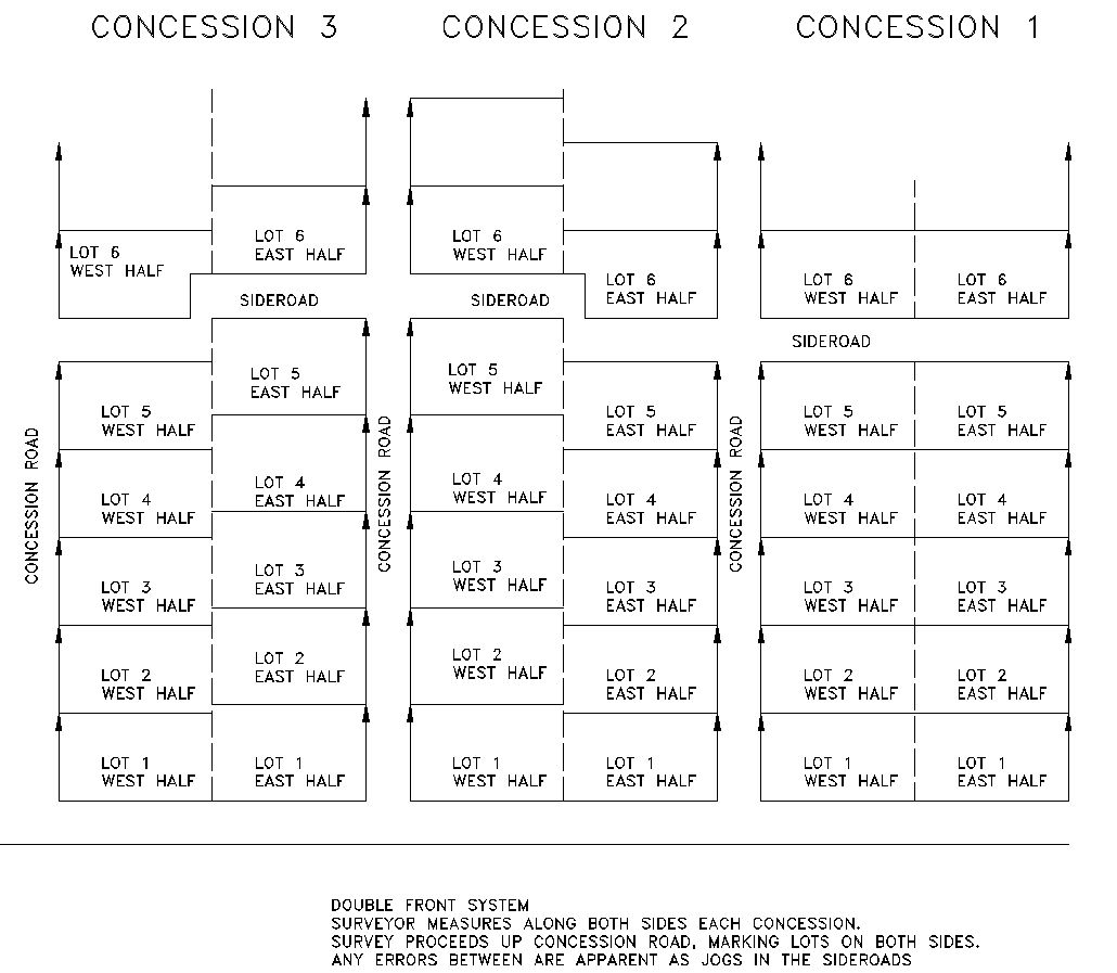
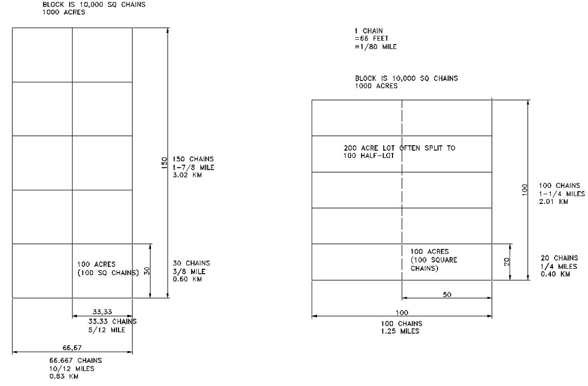
Surveyors employed several different systems to lay out townships, resulting in a complex patchwork across Ontario. By one count, there were five major systems with 166 variations, creating a pattern often described as a crazy quilt. The single-front system, one of the earlier methods, measured lots from one side of a concession to the other, which could lead to offset intersections at side roads due to survey errors. This was refined into the double-front system, where lots were measured from the front and back of the concession to a midpoint, creating even road junctions but potentially causing jogs at the midpoint of the side road. As settlement moved further from the St. Lawrence River, other systems developed. A common square grid layout known as the 1,000-Acre Sectional System had concession roads 100 chains or 1 1/4 miles apart, enclosing ten 100-acre lots each 20 by 50 chains. Another system used 100-acre lots each 30 by 33 1/3 chains, again arranged in 1000-acre blocks, with concession roads 5/6 of a mile apart and sideroads 1 7/8 miles apart.
Special colonization roads were sometimes run diagonally across the standard grid to accommodate geography or settlement patterns, creating another layer of complexity. Survey lines that referenced back from the Great Lakes often ran at different angles, creating triangles and other irregular shapes known as gores. Some townships, such as Holland, Nelson, and Toronto Township (modern Mississauga), experienced more than one survey, adding to the local complexity. In many cases, natural obstacles interfered with the grid, necessitating the creation of given roads as special routes to maintain connectivity around features like swamps or rock outcrops. The result of these varied approaches is a landscape where the regularity of the grid is frequently interrupted by these historical surveying decisions.
Terminology and Physical Characteristics
The concession road system introduced a specific vocabulary that remains in use in property records and local geography. A road allowance refers to the strip of land, typically 66 feet or one chain wide, reserved for a public road between lots. An unopened road allowance is a public highway that has been surveyed but not opened and assumed for maintenance by a township bylaw. The first concession road in a township was often called the baseline, a term from surveying, and many municipalities like Ottawa, Clarington, and London still have roads with this name today. This first road was also frequently called the front, while a concession along a lake shore was specifically termed a broken front due to its irregular shape following the shoreline. A townline is a boundary line or road between two townships, such as the Adjala-Tecumseth Townline. Given roads were special routes created to avoid natural obstacles that disrupted the perfect grid, and a gore refers to a triangular shaped lot created by intersecting survey lines at odd angles.
Numbering and Naming Conventions for Concessions
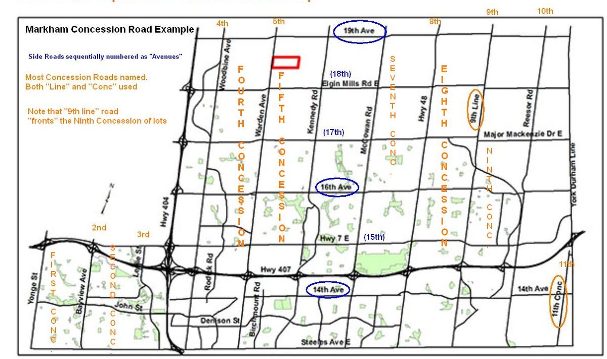
There is considerable variation in how concession roads are numbered and named across different townships, with no single provincial standard. In some areas, like Markham, roads are called both Ninth Line and 11th Concession Road interchangeably. Numbering often starts sequentially from one side of a township. In King Township, concessions start from Yonge Street, making Bathurst Street the former Second Concession road that forms the front of the second concession of land, with no first concession road existing as a named route. In other systems, a baseline runs through the middle of a township, with concessions numbered on each side, as seen in Peel Region and Dufferin County where Hurontario Street acts as the centre line. In these areas, concession roads to the east and west are numbered accordingly, using abbreviations like EHS for East of Hurontario Street and WHS for West of Hurontario Street in Dufferin County records. In present-day Mississauga, which has two surveys divided by Eglinton Avenue, Kennedy Road is the former First Line East in the northern survey and McLaughlin Road is the former First Line West.
In Warwick Township in Lambton County, the Egremont Road was the baseline, with concessions numbered North of the Egremont Road (NER) or South of the Egremont Road (SER) in official designations. In Bruce County, a unique system assigned each side of a road a separate concession number, so the south side might be Concession 2 and the north side Concession 3. For road signage, only even numbers were used, so concession roads were successively numbered 2, 4, 6, etc. Under this system, odd-numbered concession numbers would appear only in property records, such as Lot 18, Concession 11, Brant Township, which would be located on the north side of the road signed as Concession Road 10. Many concession roads retain their original numbered names, with less developed areas often referred to colloquially as back concessions.
Side Road Numbering and Modern Naming
Side road or sideline numbering followed its own set of local conventions, distinct from concession road numbering. In King Township, sideroads were numbered consecutively after the concessions. Since the last concession was 13, the first sideroad was 14, the next 15, and so on. Similarly, in Markham, the 13th concession is proceeded by 14th Avenue, which was formerly the 14th Side road. In many townships in Bruce County, sidelines were numbered in multiples of 5, i.e., 5th, 10th, 15th, and so on, starting from the town line, with five lots between each pair of successive sidelines in the original survey. In this system, the side road number was directly tied to the adjacent lot number. For many years, a process has been underway to replace numbered side roads with proper names for quicker location by emergency services. For example, most of Renfrew County's side roads now have names such as Stokes Road, Patterson Road, Dillabough Road, and Cheese Factory Road, a renaming process that has been ongoing across the province.
Enduring Impact on Ontario's Urban and Rural Landscape
The concession road grid, established before widespread urban development, has left a permanent imprint on the geography of Ontario. The rectangular survey patterns dictate the street layouts of most cities and towns across the province. In urban areas, many former concession roads have become major arterial streets, forming the backbone of municipal transportation networks and often retaining their historic names. Notable examples include Brown's Line, Ninth Line, and Guelph Line in Toronto and its western suburbs, where the Line designation persists as a direct link to the survey system. The system also continues to define rural address systems and property boundaries, with concession and lot numbers remaining key identifiers in legal land descriptions used in deeds and municipal records. This historical infrastructure supports modern agricultural tourism and community events, as seen with Farm Crawl Hamilton, where visitors travel along concession roads to visit participating farms.
Concession Roads in Modern Culture and Events
Concession roads remain active venues for community events that celebrate local history, commerce, and agriculture. In Hamilton, Concession Street is the site of the annual Concession StreetFest, a major event scheduled for Saturday, June 6, 2026, running from 9:00 AM to 6:00 PM and featuring a full street closure for vendors and activities. The broader region also hosts Farm Crawl Hamilton, an annual event where multiple farms open to the public to foster a greater appreciation for local agriculture. The 2026 season begins on Saturday, June 20, with subsequent events on July 18 and September 19, and participants can drive from farm to farm along concession roads from 10 a.m. to 4 p.m. The participating farms for the June 2026 crawl include a diverse range of operations, such as Maple Ridge Acres on Concession 11 East in Freelton, which is home to alpacas and offers ice cream, and Struyk Farm Market on Concession 4 West in Troy, which offers wagon rides to see planted crops. Other notable participants are West Avenue Cider on Concession 8 East in Freelton, with self-guided orchard tours and cider samples, Angora Springs with sheep and chickens, Between the Vines with Highland cattle, and Manorun Organic Farm featuring wagon rides and pony grooming.
These events leverage the historic road network to connect the public with local food producers and rural heritage, with tickets priced at $5 for children, $10 for seniors, $20 for adults, and $50 for a season pass for all three crawls. Other heritage events, such as Doors Open Hamilton, often feature historic sites located along or near these original survey roads. The event includes sites like the Ancaster Old Township Hall, built in 1870 by William H. Thuresson, and the Balfour House (Chedoke Estate), built in 1836 on a site overlooking the escarpment. Events like the Haunted Heritage Tours at the Canadian Transportation Museum and Heritage Village in October 2026 utilize the pathways of recreated historic villages, which often mimic the concession road grid, to explore local stories and history during evening walks from 8:30 pm to 9:30 pm on multiple dates.
Comparative Survey Systems and Lot Layouts
The various survey systems resulted in distinct physical layouts for townships across Ontario. In a single-front survey system, lots were measured from one side of the concession to the other, which caused errors to become apparent at road junctions. This system was refined to a double-front system where lots were measured from the front and back of the concession to a midpoint, making road junctions even. Other colonial surveying plans used different layouts and lot sizes of 100, 150, 160, 200, or 320 acres.
| Survey System | Concession Road Spacing | Typical Lot Size | Lot Dimensions | Notable Feature |
|---|---|---|---|---|
| Single-Front | Varies | Varies (e.g., 100-200 acres) | Measured side to side | Jogs appear at side road intersections. |
| Double-Front | Varies | Varies (e.g., 100-200 acres) | Measured front/back to midpoint | Even intersections, jogs at sideroad midpoint. |
| 1,000-Acre Sectional System | 100 chains (1 1/4 miles) | 100 acres | 20 by 50 chains | Ten lots per square block. |
| 30 by 33 1/3 Chain System | 5/6 mile (1.3 km) | 100 acres | 30 by 33 1/3 chains | Concession roads are closer together than in the sectional system. |
Questions about Concession road
What is a concession road in Ontario?
A concession road is a public roadway originally laid out by colonial surveyors to provide access to rows of farm lots conceded by the Crown to settlers. They were established before settlement, shaping the future street patterns of cities and towns. The system included road allowances, usually 66 feet wide, reserved for public travel between properties. Title to the adjacent lots was awarded to settlers in exchange for building a house, performing roadwork, land clearance, and a monetary payment.
Why are some roads called 'Line' and others 'Concession'?
The terms Line and Concession are often used interchangeably for the same type of road, but usage varies by township. In some townships, the line road name was specifically applied to the roads that elsewhere were called concession roads. The naming convention often depended on the specific survey system and historical preferences of the local municipality. In some cases, Line persists as the street designation for major thoroughfares that originated as concession roads, such as Ninth Line or Guelph Line.
How were concession roads numbered?
Numbering systems for concession roads were not uniform and could be sequential, radial from a baseline, or based on the side of the road. In sequential systems like King Township, concessions start from a boundary like Yonge Street and are numbered 1, 2, 3, etc. In radial systems like Peel Region, Hurontario Street is the centre line with concessions numbered east or west of it. In Bruce County, a unique system assigned consecutive numbers to each side of a road, but only even numbers were used for signage. This complexity means the same physical road might have different designations in property records versus on street signs.
What is the difference between a concession road and a sideline?
Concession roads are the primary roads running the length of a township, usually parallel to a lake shore or county boundary, and they separate consecutive rows of lots. Sidelines or sideroads are the cross-cutting roads that run perpendicular to them, completing the grid and providing access across concessions. Sidelines were also numbered, sometimes sequentially after concessions or in multiples of five related to adjacent lot numbers. In many areas today, sidelines have been given proper names instead of numbers for easier navigation and emergency response.
Are concession roads still important today?
Yes, concession roads remain critically important to Ontario's infrastructure, identity, and daily life in both urban and rural settings. They form the foundational grid for many urban street networks, with former concession roads like Brown's Line in Toronto becoming major thoroughfares. They continue to define rural addressing and property boundaries in legal land descriptions. They facilitate modern activities like agricultural tourism, as seen with events such as Farm Crawl Hamilton.
What are some examples of events held on concession roads?
Several community events are hosted on or centred around concession roads. The Concession StreetFest in Hamilton is a major street festival scheduled for June 6, 2026. Farm Crawl Hamilton is an annual agricultural tour where visitors drive along concession roads to visit multiple farms on specified dates like June 20, July 18, and September 19, 2026. These events include farms located on specific concessions, such as Maple Ridge Acres on Concession 11 East and Struyk Farm Market on Concession 4 West. Other heritage events, like Doors Open Hamilton and Haunted Heritage Tours, also feature sites accessible via these historic routes.
Sources and further reading
- Concession road (Wikipedia)
- Events, South Western Ontario Heritage (swoheritage.ca)
Checked by the Nosy Mag desk. Last updated 2026-10-29.