Census geographic units of Canada
Census geographic units of Canada are the standardized areas defined by Statistics Canada for the collection, analysis and dissemination of national census data. These units form a hierarchical system that organizes the country from its largest provinces and territories down to its smallest neighbourhood blocks, solely for statistical purposes. They provide the essential geographic framework that enables the accurate measurement of Canada's population, housing and social characteristics every five years. The data derived from these units inform critical decisions on public services, infrastructure and resource allocation at all levels of government and within communities across the nation.
Hierarchical Structure and Purpose
The census geographic hierarchy is designed to aggregate data from small areas into larger, meaningful regions for analysis. At the top of the structure are Canada's provinces and territories, which serve as the first-level geographic units. These are subdivided into second-level census divisions, which in turn contain third-level census subdivisions. The smallest building blocks in the system are fourth-level dissemination areas. This nested structure ensures data can be summarized and compared consistently across the country. The geographic units exist purely for statistical reporting and have no independent governance or administrative functions. Statistics Canada maintains and updates the boundaries of these units, often in collaboration with provincial and territorial governments, to reflect changes in municipal borders and population patterns. The integrity of this geographic framework is fundamental to the reliability of census data used for planning schools, hospitals, transportation and emergency services.
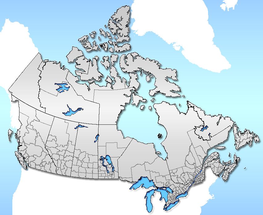
Census Divisions and Consolidated Subdivisions
Census divisions represent an intermediate geographic area between the province or territory level and the municipality. In six provinces, these divisions are legislated groupings of adjacent census subdivisions that share in regional planning and management of services. In four provinces and all three territories, where no equivalent legislated areas exist, Statistics Canada collaborates with provincial and territorial authorities to create statistical equivalents. The classification terms for census divisions vary across the country and include county, district, district municipality, region, regional county municipality, regional district, regional municipality, territory, united counties, and simply census divisions. In the prairie provinces, census divisions are statistical groupings that do not correspond to a single administrative level but rather group multiple administrative divisions together. Within some census divisions, Statistics Canada may define census consolidated subdivisions. These are combinations of adjacent census subdivisions, typically consisting of larger, more rural census subdivisions and smaller, more densely populated ones. This consolidation allows for more meaningful statistical reporting in regions where individual municipalities may be too small for detailed analysis on their own.
Census Subdivisions and Small Area Geography
Census subdivisions are the third level in the hierarchy and generally correspond to municipalities as determined by provincial or territorial legislation. Where incorporated municipalities do not exist, Statistics Canada establishes statistical equivalents in cooperation with provincial authorities, particularly in British Columbia, Newfoundland and Labrador, and Nova Scotia. Common examples of these equivalents include Indian reserves, Indian settlements and unorganized territories. The criteria for Indian reserve and Indian settlement census subdivisions are established by Indigenous and Northern Affairs Canada. Below the census subdivision level are two smaller standard geographic units that cover the entire country. Dissemination areas are the second-smallest unit, comprising one or more dissemination blocks and having a population between 400 and 700 persons. The smallest standard unit is the dissemination block, which is an area bounded by visible features like roads or by the borders of higher-level geographic units. These small areas are the essential building blocks for creating all larger census geographies, including population centres and census tracts.
Urban and Specialized Statistical Areas
Beyond the standard hierarchy, Statistics Canada defines several specialized geographic units to analyze urban and social patterns. A census metropolitan area is a grouping of census subdivisions comprising a large urban core of at least 100,000 people and closely integrated surrounding urban fringes. CMA status is retained even if the core population later drops below 100,000. The Ottawa-Gatineau CMA is the only one that crosses a provincial border. A census agglomeration is a smaller version with an urban core population greater than 10,000 but less than 100,000. If the population of an urban core is less than 50,000, it is the starting point for the construction of a census agglomeration. CMAs and CAs with populations over 50,000 are subdivided into census tracts, which have populations ranging from 2,500 to 8,000. The population centre geography, introduced in 2011, replaces the former urban area classification. A population centre is any grouping of contiguous dissemination areas with a minimum population of 1,000 and an average density of 400 persons per square kilometre. In 2011, Statistics Canada identified 942 population centres across the country. Population centres are further categorized as small (1,000 to 29,999), medium (30,000 to 99,999), or large urban (100,000 and greater). Some population centres cross municipal boundaries.
Other specially-defined units include designated places, which are usually small communities that do not meet the criteria for municipalities or population centres but for which Statistics Canada or a provincial government requests demographic data. Localities are historical named locations such as former census subdivisions, former urban areas, neighbourhoods, or unincorporated places. Federal electoral districts are another unit for which Statistics Canada aggregates data to support the electoral boundary redistribution process that occurs every ten years, with each district receiving a unique five-digit code. The methodology used by Statistics Canada does not allow for CMA-CMA mergers into larger statistical areas, so there is no Canadian equivalent to the United States' combined statistical areas.
The 2026 Census and Data Utilization
The next Census of Population will be conducted on May 4, 2026, continuing the mandatory quinquennial cycle. All Canadian households will receive an invitation letter in the mail with instructions for completing the questionnaire, which collects vital demographic, social and economic information. The data gathered against the framework of census geographic units paints a detailed statistical portrait of the nation and its diverse population. This information supports countless private and public sector decisions, from business market analysis to government policy development and the redrawing of federal electoral districts. Statistics Canada has scheduled the release of 2026 Census geographic and reference products for November 18, 2026. The agency places the highest priority on protecting the confidentiality of individual responses, which are collected under the authority of the Statistics Act. The resulting data ensures that community planning for schools, daycare, housing and infrastructure is based on accurate, timely and granular information reflective of Canada's changing society.
Provincial and Territorial Variations
The application and nomenclature of census geographic units vary significantly across Canada due to differing provincial and territorial administrative structures. In six provinces, census divisions correspond to legislated entities such as counties or regional municipalities. In the prairie provinces of Alberta, Saskatchewan and Manitoba, census divisions are statistical groupings that do not correspond to a single level of local government but rather group multiple administrative divisions together. In Newfoundland and Labrador, the boundaries are set by Statistics Canada as no such level of government exists. Two of Canada's three territories, the Northwest Territories and Nunavut, are also divided into census divisions. In Quebec, the units are regional county municipalities, while in British Columbia they are regional districts. This flexibility within the national standard allows the geographic framework to meaningfully represent the diverse political and settlement landscapes found across the country while maintaining consistency for national data comparison.
Data Products and Public Access
Statistics Canada produces a wide array of data products and reference materials based on the census geographic units. These include reference maps that visually depict the boundaries of census divisions, subdivisions, dissemination areas and other units. The agency also maintains online resources such as a hierarchy of census geography and tables listing geographic areas by province and territory. The data from each census are released in multiple waves, starting with population and dwelling counts for various geographic levels, followed by more detailed thematic data on topics like language, income and housing. The geographic framework itself is a key reference product, with updates released to reflect boundary changes between census cycles. Public access to this geographic data enables researchers, municipal planners, businesses and community organizations to conduct their own spatial analyses and understand local demographic trends. The upcoming release of 2026 geographic products on November 18, 2026, will provide the updated framework for analyzing the new census data.
Comparative Statistics and National Context
The standardized nature of census geographic units allows for powerful comparisons across time and space within Canada. For example, one can track population growth in a specific census tract over several decades or compare average household income between different census metropolitan areas. The table below illustrates the hierarchy and typical characteristics of the primary geographic units, showing how they nest within one another. This structure ensures that whether analyzing the remote regions of Nunavut or the dense neighbourhoods of downtown Montreal, the data is organized in a consistent manner. The units also allow Canada to participate in international statistical comparisons, as many countries use similar hierarchical geographic frameworks for their national censuses. The stability of units like census tracts and census divisions is crucial for longitudinal studies that track social and economic changes within communities over time.
| Geographic Unit Level | Description | Typical Population Range | Examples / Equivalents |
|---|---|---|---|
| First-Level | Provinces and Territories | Millions | Ontario, Yukon |
| Second-Level | Census Divisions | Varies widely | County, Regional Municipality, Regional District |
| Third-Level | Census Subdivisions | Varies widely | City, Town, Indian Reserve, Unorganized Territory |
| Fourth-Level | Dissemination Areas | 400 to 700 | Group of city blocks, rural area |
| Below Fourth-Level | Dissemination Blocks | Not published | Area bounded by roads |
| Specialized Unit | Census Metropolitan Area (CMA) | 100,000+ core | Toronto, Vancouver, Ottawa-Gatineau |
| Specialized Unit | Census Agglomeration (CA) | 10,000 to 100,000 core | Kamloops, BC. Drummondville, QC |
Questions about Census geographic units of Canada
What is the smallest census geographic unit in Canada?
The smallest standard census geographic unit in Canada is the dissemination block. These blocks cover the entire country and are defined as areas bounded by visible features such as roads or by the borders of higher-level geographic units. Dissemination blocks are the foundational building blocks from which all larger census units, including dissemination areas and population centres, are constructed. Statistics Canada does not publish population or dwelling count data for individual dissemination blocks to protect privacy.
How is a census metropolitan area different from a city?
A census metropolitan area is a statistical concept that represents a large, integrated urban region, not a political entity. It consists of one or more adjacent municipalities centred on a major urban core of at least 100,000 people. A CMA includes the core city plus any surrounding census subdivisions where commuting and economic integration meet specific thresholds. In contrast, a 'city' is a specific type of incorporated municipality with its own local government. A single CMA, like Toronto or Vancouver, contains many individual cities, towns and other municipalities within its boundaries.
Why does Statistics Canada create census divisions in some provinces?
Statistics Canada creates or recognizes census divisions in all provinces and territories to provide a stable, intermediate geographic level for data comparison and regional analysis. In six provinces, these divisions are legislated groupings of municipalities that share services like regional planning and emergency response. In four provinces and all three territories, equivalent legislated areas do not exist, so Statistics Canada collaborates with these governments to create statistical equivalents. In Newfoundland and Labrador specifically, the agency sets the boundaries directly because no such level of government exists in the province.
What is a designated place?
A designated place is a small community or settlement that does not meet the criteria used to define incorporated municipalities or population centres. These are often unincorporated villages, resort communities or other small population clusters. A provincial or territorial government or Statistics Canada can request the designation to enable the compilation of local demographic statistics. Designated places allow residents and planners in these communities to access census information specific to their area.
When will data from the 2026 Census be released?
Statistics Canada will begin releasing data from the 2026 Census in stages. The census itself will be conducted on May 4, 2026. The first major release of geographic and reference products, which includes updated boundaries and codes for all census geographic units, is scheduled for November 18, 2026. This staged release ensures that the geographic framework is available before the subsequent publication of population and demographic data.
Can census geographic boundaries cross provincial borders?
Yes, certain statistical geographic units can cross provincial borders, though this is rare. The primary example is the census metropolitan area of Ottawa-Gatineau, which includes the city of Ottawa in Ontario and the city of Gatineau in Quebec. However, the standard hierarchical units like census divisions and census subdivisions cannot cross provincial or territorial boundaries. These lower-level units are based on the administrative frameworks established by each individual province and territory.
Sources and further reading
- Census geographic units of Canada (Wikipedia)
- 2026 Canadian Census (middlesexcentre.ca)
Checked by the Nosy Mag desk. Last updated 2026-10-26.