Distant Early Warning Line
The Distant Early Warning Line, also known as the DEW Line or Early Warning Line, was a system of radar stations in the northern Arctic region of Canada, with additional stations along the north coast and Aleutian Islands of Alaska, the Faroe Islands, Greenland, and Iceland. It was set up to detect incoming bombers of the Soviet Union during the Cold War and provide early warning of any sea-and-land invasion. The DEW Line was the northernmost and most capable of three radar lines in Canada and Alaska. The system stretched nearly 10,000 kilometres, comprising 63 sites, and represented one of the most ambitious and logistically challenging military construction projects of its era. Its creation and operation had a significant impact on the Canadian North, introducing new infrastructure and wage economies while altering Indigenous communities and environments. The DEW Line was officially replaced by the modernized North Warning System in 1993.
Strategic Origins and Cold War Context
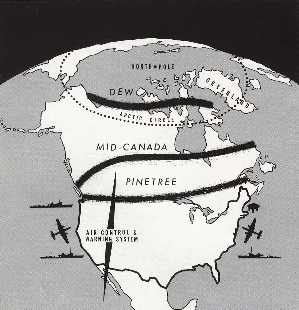
The DEW Line was conceived as a direct response to the strategic vulnerability of North America to aerial attack via the Arctic during the Cold War. The shortest route for Soviet bombers to reach major North American targets was over the North Pole, a fact that rendered existing continental defence lines inadequate. The Pinetree Line, built just north of the Canada-United States border, was completed in 1954 but was considered too far south to provide sufficient warning time. The subsequent Mid-Canada Line, using bistatic radar technology at the 55th parallel, proved largely useless in practice as the radar return of flocks of birds overwhelmed signals from aircraft. A 1952 study by a group of prominent scientists at the Massachusetts Institute of Technology, known as the Summer Study Group, concluded that a distant early warning line across the high Arctic was urgently needed. This recommendation led to a formal bilateral agreement between the Canadian and United States governments on 15 February 1954, authorizing the construction of a third, far northern radar line. The project was given the highest national priority, with the United States agreeing to finance the construction while employing Canadian labour as much as possible.
Logistical Feat of Construction
The construction of the DEW Line was a monumental engineering and logistical undertaking, described as building entire communities in some of the most hostile and isolated environments on the continent. Advance site preparation began in December 1954, with a target completion date of 31 July 1957, allowing only about six months of work during two short Arctic summers. The project required the recruitment, transportation, and support of approximately 25,000 skilled workers from across the United States and southern Canada. A massive sealift operation during the brief ice-free periods was crucial, with over 3,000 specially trained United States Army Transportation Corps soldiers deployed to unload ships. The effort was supported by innovative vehicles like the TC-264 Sno-Buggy, a massive six-car, 24-wheel-drive overland train designed for Arctic conditions. Air transport formed the backbone of winter operations, with ski-equipped Lockheed C-130D Hercules aircraft and other cargo planes moving critical supplies. In total, 460,000 short tons of materials were moved from southern locations to the Arctic by air, land, and sea. Subcontractors handled the on-site construction, which involved producing vast quantities of gravel, pouring concrete in extreme cold, and erecting buildings, steel antenna towers, airstrips, and hangars. The line ultimately consisted of 63 stations stretching from Alaska to Baffin Island. The construction process followed successful prototype testing in Alaska and a training prototype in Streator, Illinois. Siting crews, working under primitive conditions using airplanes, snowmobiles, and dog sleds, determined the final locations along a route roughly following the 69th parallel north. The project was completed on schedule, with the Western Electric Company turning over a complete, operating radar system to the air forces on 15 April 1957. Key construction challenges and methods included:
- Use of prefabricated modular building units assembled at Point Barrow, Alaska, and hauled by tractor to remote sites.
- Design of permanent H-shaped buildings pointed into prevailing winds and built high off the ground to combat drifting snow.
- Development of specialized communication infrastructure, notably the White Alice tropospheric scatter radio system.
- Construction of four DYE stations as an extension across the Greenland ice cap, supported from Iceland.
- Installation and rigorous testing of all radar and communications equipment across the integrated network.
System Design and Operations
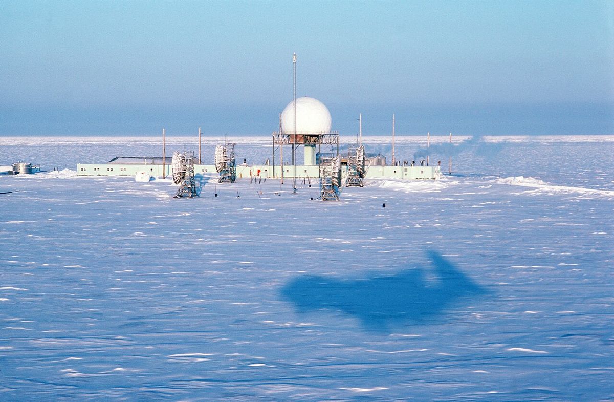
The DEW Line was designed as an integrated detection and characterization system, a significant advancement over the simpler trip wire function of the Mid-Canada Line. It used conventional L-band search radars, primarily the AN/FPS-19, which could provide information on the size and direction of an attack. The stations were strategically placed approximately 160 kilometres apart. The system architecture featured three types of stations to ensure coverage and manage resources. Main stations were large, self-contained communities with populations of 40 to 70 people, featuring parallel module buildings connected by a bridge, their own airstrips, and amenities like libraries. Auxiliary stations were smaller, housing 14 to 20 personnel in a single modular building. Initially, there were also unstaffed Intermediate stations, but these proved ineffective and were decommissioned. Small, automated gap filler stations, checked only occasionally, used AN/FPS-23 Doppler radar to monitor areas between the main sites. Operations were continuous, with radar consoles manned 24 hours a day, 365 days a year for 36 years. The system was a fundamental component of the new North American Aerospace Defense Command (NORAD) established in 1958. Day-to-day operations and maintenance were performed primarily by Canadian and American civilian technicians, with military personnel limited to main stations and annual inspections. All installations flew both the Canadian and United States flags. The radar data was fed into the Semi-Automatic Ground Environment (SAGE) computer network and ultimately centred at the Cheyenne Mountain Complex, NORAD's command hub. The system was later upgraded with new AN/FPS-117 radars beginning in 1985 as part of the transition to the North Warning System.
Technical Specifications and Upgrades
The core search radar technology of the original DEW Line was the AN/FPS-19. Supporting equipment included lateral and long-range communications dishes like the AN/FRC-45 and AN/FRC-101. The system required significant modifications to function in the Arctic environment, including adjustments to reduce vibration from temperature changes and an increase in pulse duration for more stable readings. The technical specifications of key components illustrate the system's capabilities and limitations. The system was designed to detect bombers, not intercontinental ballistic missiles (ICBMs), a threat addressed separately by the Ballistic Missile Early Warning System (BMEWS) constructed in 1958. The DEW Line was upgraded with fifteen new AN/FPS-117 passive electronically scanned array radar systems between 1985 and 1994, and the line was then renamed the North Warning System.
| System/Parameter | Specification |
|---|---|
| Primary Search Radar | AN/FPS-19 |
| Gap Filler Radar | AN/FPS-23 Doppler |
| Frequency Range (AN/TPS-1D) | 1.22 to 1.35 GHz |
| Peak Power Output | 160 kilowatts |
| Detection Range | Up to 160 nautical miles (300 km) |
| Key Upgrade (1985 to 1994) | AN/FPS-117 phased array radar |
| Successor System | North Warning System (NWS) |
Impact on Northern Canada and Indigenous Communities
The construction and decades-long operation of the DEW Line fundamentally transformed the human and physical environment of the Canadian Arctic. The project introduced southern-style infrastructure, including airports, roads, and modern buildings, to previously remote locations. For many Inuit and Gwich’in communities, the DEW Line sites served as their first major exposure to wage labour and a cash economy, with some Indigenous workers employed in construction and later operations. However, consultation for building sites was minimal, and the long-term social and environmental impacts were not initially considered by the governments or the main contractor, Western Electric. The presence of the stations, with their housing, services, and employment opportunities, encouraged the movement of Indigenous peoples into more centralized communities, accelerating cultural change. The legacy is described by Inuit leaders as mixed. While the aviation and other infrastructure built for the DEW Line became the core transportation links for modern Northern communities, the development was not conceived with Inuit needs in mind. The environmental impact was severe, with widespread contamination from polychlorinated biphenyls (PCBs), asbestos, and fuels. Thousands of 55-gallon fuel drums and open dumps of debris were left scattered across the tundra. The Canadian government later undertook a massive and costly remediation project to decommission 21 sites, a clean-up that took 15 years. In 1996, the United States Government agreed to deposit US$100 million into Canada's Foreign Military Sales Trust Account as compensation for the cleanup costs of the DEW Line and other projects.
Transition to the North Warning System and Current Status
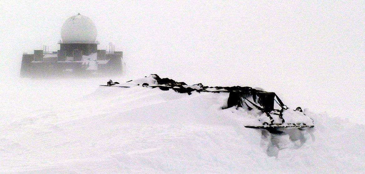
By the 1980s, advances in technology and changing threat perceptions, including a greater focus on cruise missiles and newer generations of aircraft, rendered the original DEW Line increasingly obsolete. In 1985, during the Shamrock Summit, Canada and the United States agreed to replace it with a more modern and automated system. This led to the creation of the North Warning System (NWS). The transition involved deactivating most of the original DEW Line stations between 1988 and 1993, while a select number were upgraded with new AN/FPS-117 long-range radars and AN/FPS-124 short-range radars. The official handover from the DEW Line to the NWS occurred on 15 July 1993. Today, the physical remnants of the DEW Line are largely gone, either dismantled, remediated, or incorporated into the NWS. The NWS itself is now aging, and with renewed geopolitical tensions and advances in surveillance technology, its future is under review. The Canadian government has committed to modernizing NORAD capabilities, including in the Arctic, though specific plans for replacing the North Warning System remain under development.
Organizational Structure and Manpower
The DEW Line was a binational endeavour managed through a complex structure involving military commands and civilian contractors. The majority of Canadian stations were under the joint responsibility of the Royal Canadian Air Force (RCAF) and the United States Air Force (USAF). The USAF component was the 64th Air Division of Air Defense Command, with logistical and contractual support provided by the 4601st Support Squadron based in Paramus, New Jersey. Day-to-day operations were heavily reliant on a civilian workforce. Western Electric, as the prime contractor, oversaw construction and initial operations, with much of the staffing and maintenance later managed by other civilian firms. Personnel were a mix of American and Canadian civilians, with military presence focused on oversight and inspection. The stations formed isolated, self-sufficient communities, especially the main sites, which had to provide all essential services for their personnel year-round. In 1958, the line became a base of the new North American Aerospace Defense Command (NORAD) organization.
Atlantic and Pacific Barrier
The DEW line was supplemented by the Contiguous Radar Coverage System, which included two barrier forces in the Atlantic and the Pacific oceans operated by the United States Navy from 1956 to 1965. These barrier forces consisted of surface picket stations, dubbed Texas Towers, a surface naval force of 12 radar picket destroyer escorts and 16 Guardian-class radar picket ships, and an air wing of Lockheed WV-2 Warning Star aircraft that patrolled the picket lines. Their objective was to extend early warning coverage against surprise Soviet bomber and missile attack as an extension of the DEW Line. The Atlantic Barrier (BarLant) consisted of two rotating squadrons, one based at Naval Station Argentia, Newfoundland, to fly orbits to the Lajes Field in the Azores and back, and the other at Naval Air Station Patuxent River, Maryland. The Pacific Barrier (BarPac) began operations with one squadron operating from Naval Air Station Barbers Point, Hawaii, and a forward refuelling base at Naval Air Facility Midway Island, on 1 July 1958. Barrier Force operations were discontinued by September 1965 and their EC-121K aircraft placed in storage.
Questions about Distant Early Warning Line
How many DEW Line stations were there and where were they located?
The original DEW Line consisted of 63 radar stations stretching approximately 10,000 kilometres across the Arctic. The main line ran along the 69th parallel north, about 320 kilometres north of the Arctic Circle, from western Alaska across northern Canada to Baffin Island. The system also included extensions known as DYE stations on the Greenland ice cap, with support from Iceland and the Faroe Islands, and stations along the Aleutian Islands in Alaska. The stations were categorized as Main, Auxiliary, and Intermediate sites, spaced roughly 160 kilometres apart to ensure overlapping radar coverage.
Who built the DEW Line and how long did it take?
The DEW Line was built under a bilateral agreement between the United States and Canadian governments. The United States financed the project, while Canada provided logistical support and labour. The prime contractor was the Western Electric Company, a subsidiary of the Bell System, which coordinated a vast network of subcontractors. Construction began in earnest in December 1954 after site surveys and prototyping. Despite the extreme Arctic conditions, the entire system was built and declared operational in just 32 months, with the handover to the air forces occurring on 15 April 1957. At its peak, the construction project employed about 25,000 people.
What happened to the DEW Line sites?
Most original DEW Line stations were deactivated between 1988 and 1993 as the system was replaced by the newer North Warning System (NWS). A small number of sites were upgraded with new radar equipment and incorporated into the NWS. The remaining abandoned sites left a significant environmental legacy of contamination, including fuel drums, PCBs, and asbestos. The Canadian government undertook a major environmental remediation project, cleaning up 21 sites. In 1996, the United States agreed to provide US$100 million to Canada to help cover the cleanup costs of the DEW Line and other projects.
How did the DEW Line affect Indigenous peoples in the Canadian Arctic?
The DEW Line had a significant and mixed impact on Inuit and Gwich’in communities. It introduced wage labour, modern infrastructure like airports and housing, and accelerated the shift from a nomadic to a settled lifestyle. However, this development was imposed with minimal consultation, disrupting traditional land use and cultures. While some employment opportunities were created, the primary workforce during construction came from the south. The long-term environmental damage from abandoned sites required a massive clean-up. Inuit leaders note that the aviation infrastructure remains vital today, but the social and environmental costs were significant.
What was the purpose of the DEW Line?
The purpose of the Distant Early Warning Line was to detect incoming bombers of the Soviet Union during the Cold War and provide early warning of any sea-and-land invasion. It was built to give the earliest possible warning of a Soviet nuclear strike, allowing time for United States bombers to get off the ground and for intercontinental ballistic missiles to be launched. This system was the northernmost and most capable of three radar lines in Canada and Alaska, designed to offer hours of advance warning from its Arctic locations. Its need was considered critical, receiving the highest national priorities for construction.
What is the difference between the DEW Line and the North Warning System?
The North Warning System is the modern successor that replaced the Distant Early Warning Line. In 1985, the United States and Canada agreed to transition the DEW Line to the new North Warning System. The official handover occurred on 15 July 1993. A key difference is technological, as the DEW Line was upgraded with fifteen new AN/FPS-117 passive electronically scanned array radar systems between 1985 and 1994. Beginning in 1988, most original DEW stations were deactivated, while a small number were upgraded with all new equipment to form the North Warning System, which is more automated.
Sources and further reading
- Distant Early Warning Line (Wikipedia)
- Distant Early Warning Line, Northwest Territories Timeline (nwttimeline.ca)
- DEWLine Museum, HOME, The Distant Early Warning ... (dewlinemuseum.com)
- The DEW Line at 65: Future unclear for the North's aging ... (cbc.ca)
Checked by the Nosy Mag desk. Last updated 2026-10-24.